by Bruce L. Wiland
The purpose of this research was to verify the validity of some of the information contained on the following historical marker.
Text of the Historical Marker entitled "Falls of the Brazos River" (erected 1975)
"When Anglo-Americans began to settle in Texas, the falls of the Brazos were located 2 miles southwest of here. At that time, the water fell about 10 feet over a rocky ledge. The falls served the Indians and early settlers as a traill landmark, meeting point, and compsite. In 1834 colonizer Sterling C. Robertson (1785-1842) established the town of Sarahville De Viesca at the fall line of the west bank of the Brazos, but it was abandoned in 1836 because of Indian hostilities. Later renamed Ft. Milam, the settlement lasted only a few more years. It was followed by the town of Bucksnort, begun in the 1840s on the east side of the river. The falls also formed a natural fording place for frontier travel; the rocky stream bed was the only hard-bottom crossing of the Brazos within 200 miles of the coast. The rapids marked the limit of the river's 19th century steamboat traffic as well. Organized in 1850, Falls County was named for this distinctive landmark. Marlin became the county seat in 1851, and Bucksnort soon disappeared. The Brazos River changed course in 1866, moving the Fall line to the present site and lowering the rapids to about 2 feet. Today a county park is located along both sides of the river at the falls."
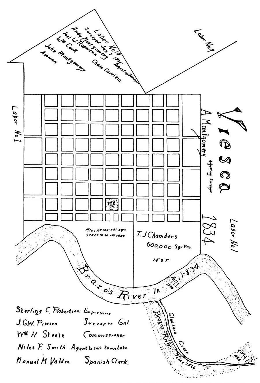
Initially, the research focused on the location of the old falls. According to the historical marker, the old falls were purported to be 2 miles to the southwest of the current falls. The earliest map we have found showing both the old and new location of the Falls appeared on page 18 of The History of Falls County, Texas, compiled by Old Settlers and Veterans Association of Falls County, Texas, Roy Eddins, Editor, 1947 which was subsequently reproduced in the publication Papers Concerning Robertson's Colony in Texas. This map was supposedly drawn by Edmund Pierson (1847-1929) using the original prepared by his father, John Goodloe Warren Pierson (1795-1849). It is unclear when Edmund Pierson drew this map, but it was obviously sometime in or after 1866 based on the notes on the drawing.
From Papers Concerning Robertson's Colony in Texas, Volume IX, compiled and edited by Malcolm D. McLean (Arlington, Texas: The UTA Press, 1982), p. 4
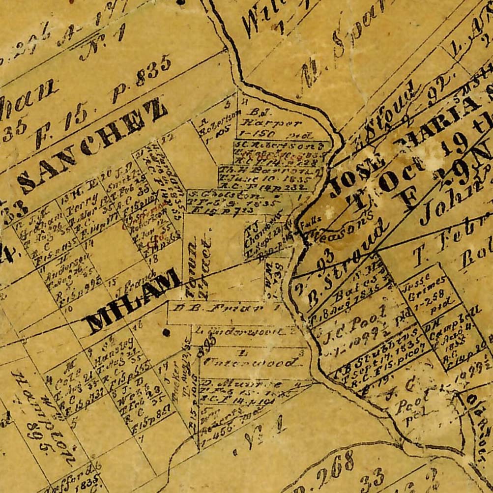
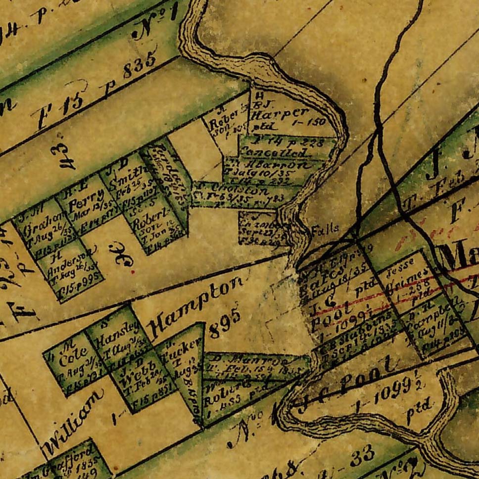
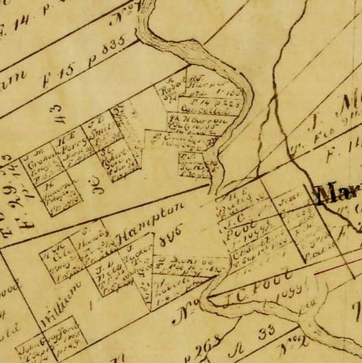
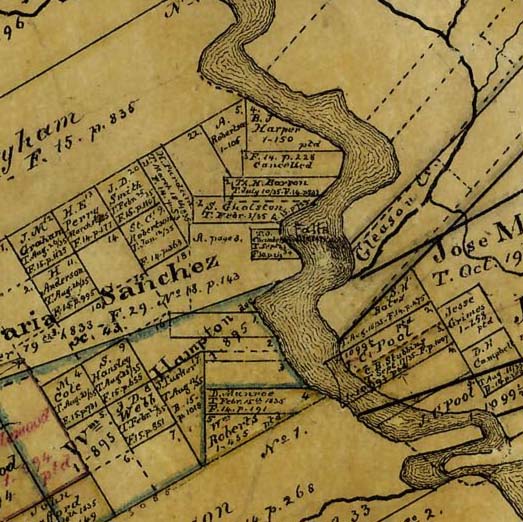
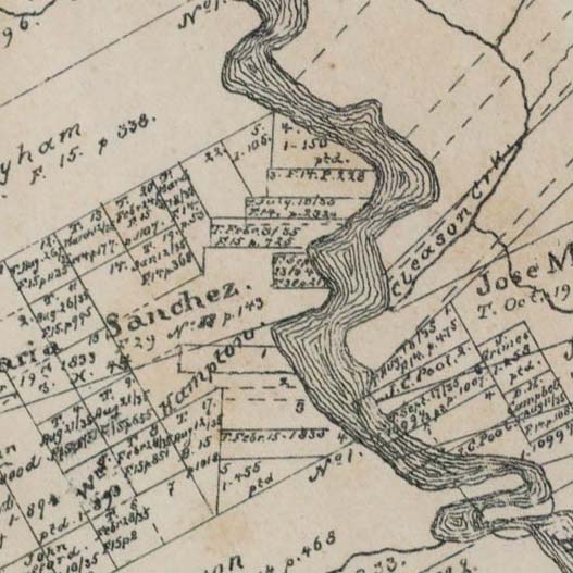
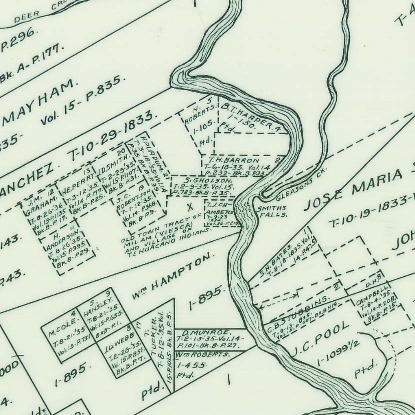
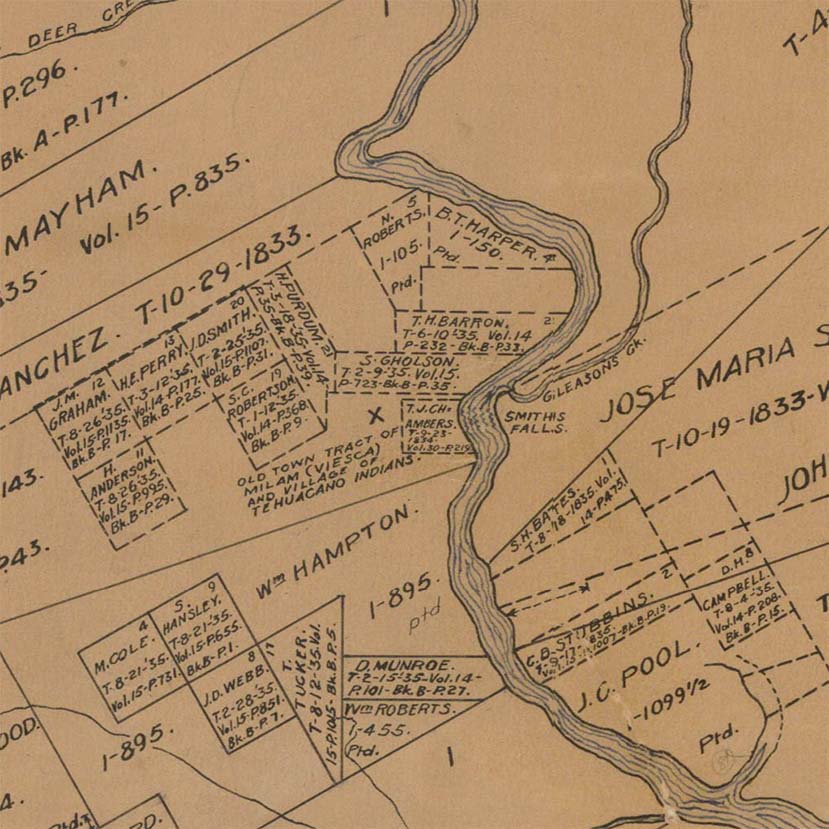
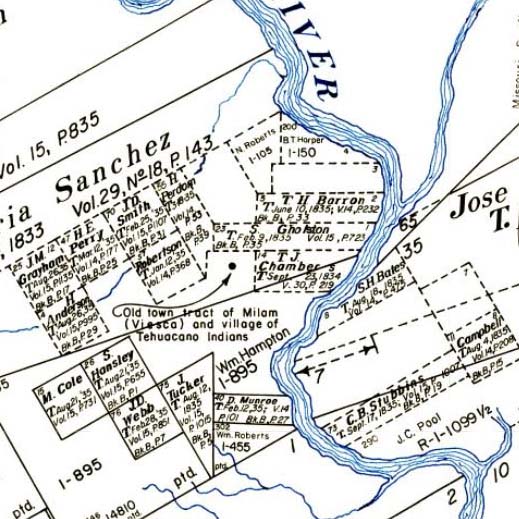
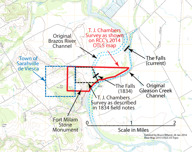
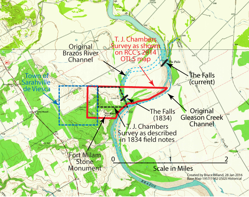
County maps from the General Land Office have shown the location of the original falls in relation to surrounding land grants. The maps below are a cropped portion of the county maps. Clicking on the title links under these maps will open a new tab showing the entire map of Falls County with the ability to zoom and navigate.
It should be pointed out that these maps were drawn based on the information in the original survey field notes and not on the actual locations of geographical features as of the date the maps were drawn. These maps, therefore, do not reflect physical changes to the streams and rivers after the date of the original survey. Using these maps, field notes from the original land grant surveys of Jose Maria Sanches and Thomas J. Chambers, and contour lines on a modern topographical map, we believe we can pinpoint where the original falls were located. The distance is less than the two miles mentioned on the historical marker. It is closer to one mile as shown below.
|
|
| As shown on a 2012 USGS Topographical Map | As shown on a 1962 USGS Topographical Map |
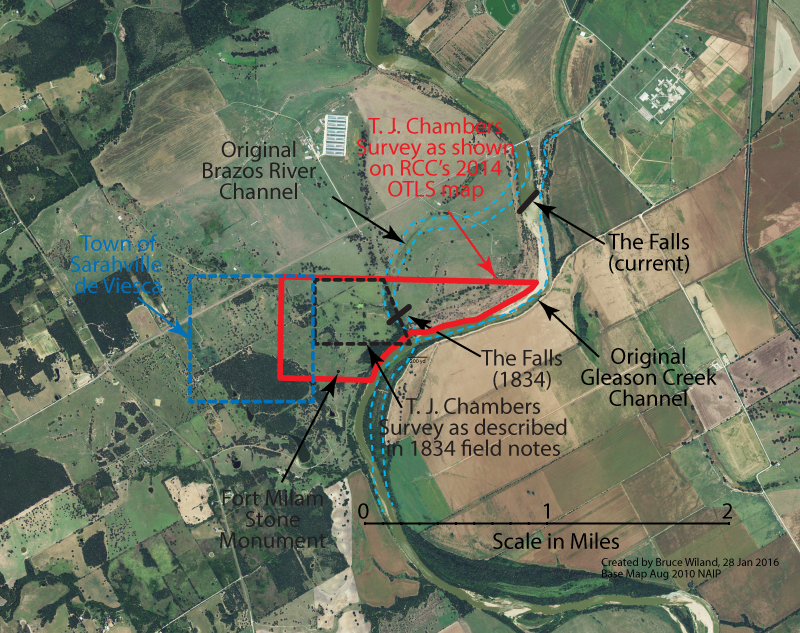
As shown on an August 2010 aerial view (NAIP)
Once the location of the old falls was determined, the research then focused on the date that the Brazos River changed course resulting in the current location of the Falls. According to the historical marker, this occurred in 1866. The earliest reference we have found concerning the change of course, other than the Edmund Pierson map, comes from the following book:
From A Memorial and Biographical History of McLennan, Falls, Bell, and Coryell Counties, (Chicago: The Lewis Publishing Company, 1893), p. 173
"The Brazos falls have not been in one place exactly, however. The great Texan river, with its 900 miles of length, and draining a vast area estimated at 35,000 square miles, has grown turbulent at times and cut a wide valley out of the deep Ponderosa marl, the greatest width being about three miles above Marlin. In this wide valley it seems to have wandered occasionally and made jtself a new bed as impulse dictated. Before it took its present course somewhat near to the western bluffs, it had a bed bending almost to the east side of the valley, but during this century it clung to the western bluffs for the most part. Crossing it diagonally almost to the south runs a ledge of limestone rock almost a mile wide in places, and tumbling over this near the western bluff were the falls of the early pioneers. A small creek, known as Gleason's creek arose in the valley along for the most part some distance below this ledge, and flowing into the Brazos bed below the falls and bending back and above some distance very near in its upper course to the Brazos again, where, should the Brazos conclude to cut across with the most of its waters, the connection would make an isiand of abont 150 acres; and newer falls, somewhat less in height and higher up on Gleason's creek, a distance of only a few miles from Marlin. This was just what happened along during the closing years of the Civil war; and now the falls, or, as they are frequently called, the rapids, furnish a pleasant destination for short summer evening drives from Marlin, and one with which her citizens are not slow in availing themselves."
This reference indicates that the river changed course in the "closing years of the Civil War" which would have made it around 1864 or 1865. It is unclear as to the source of this reference to the Civil War. A subsequent book also referred to the date that the Falls changed locations.
From History of Falls County, Texas, compiled by Old Settlers and Veterans Association of Falls County, Texas, Roy Eddins, Editor, 1947, p. 19
"Mr. Pierson, a surveyor, taking cognizance of the needs of the Company and his commission to "do all things relative to the said colony," at once designated and laid-out a capital in the area. It was located atop a hill on the west side of the river, overlooking the Falls, which, at that time, was a few miles southwest of the present Falls. (The river changed its course in the 1860s)."
From History of Falls County, Texas, compiled by Old Settlers and Veterans Association of Falls County, Texas, Roy Eddins, Editor, 1947, p. 279-280
"The channel of the river, as it passed through the alluvial valley, has changed many times. As long as the stream ran slow, it clung to its channel, but when filled by heavy rains on its great watershed, it became angry and swift. It often washed away the alluvial soil, or created new channels, depending upon the nature of the soil, soil elevations, velocity and persistency of the flow. Perhaps, the most marked shift of record took place a few years prior to 1866. Edmund Pierson, County Surveyor at one time, drew a map of old Viesca, early townsite laid out by his father, John G. W. Pierson, and upon the map appears notations of channels of the stream prior to and after 1866. Prior to the change, the falls of river was between one and one-half and two miles southwest of the present falls. Northwest of Marlin the channel shifted westward in recent years, leaving piers of the former "Rockdam Bridge" standing on dry lands about a half mile to the east, on the Dr. N. D. Buie farm. Frequently the river had changed its course, taking from, or adding to, farms on either side of the stream."
The references to "the 1860s" and "a few years prior to 1866" almost certainly came from the notations on the Edmund Pierson map. What is unclear is what Edmund Pierson meant by his notations. Was he saying that the river definitely changed course in 1866, or was he saying that he only knew that the river had changed course sometime before 1866? If he meant the latter, then the Falls could have changed location anytime between 1834 (when the Falls were originally mentioned in the land grant surveys) and 1866. The following references may shed some light on this.
From Flowers and Fruits in the Wilderness, by E. N. Morrell (Boston: Gould and Lincoln, 1872), p. 42
"The river at this time was very low at this point, -- not over knee-deep to-our horses, -- the falls about ten perpendicular feet, and the water below them abounding with fish. We examined the place minutely with reference to its capacity to run machinery. A few old Texans yet live who remember that the stream was quite narrow at this point in 1836."
In the preceding passage, Morrell describes the Falls as being10 feet high and very narrow in 1836. So, the Falls were almost certainly located at their old location in 1836.
From Texas, with Particular Reference to German Immigration and The Physical Appearance of the Country, by Dr. Ferdinand Roemer, translated from the German by Oswald Mueller, (San Antonio: Standard Printing Company, 1935), Chapter XVI, p. 206
“After the heat of the day we covered the remaining six miles to the falls of the Brazos. The road led us diagonally across the Brazos bottom, which forms here a luxuriant virgin forest which was filled with half rotted tree trunks strewn about in the wildest disorder. The so called falls are really only rapids and are caused by layers of bluish grey marlslate, belonging to the cretaceous formation, three to four feet high, lying diagonally across the river. The river was considerably broader here than downstream, but so shallow at this time of the year that we could ford it without danger.”
In the preceding passage, Roemer describes the Falls as being only three to four feet high, lying diagonally across the river, resembling rapids more than they do falls. The river and falls are described as relatively broad in width. This description was from a trip Roemer took in August, 1846. Roemer's desciption of the falls is significantly different than that of Morrell, but it is remarkedly similar to how the Falls appear today as shown in the following photo. In this photo, the length of the Falls is about 250 yards, and the river is about 150 yards wide above the Falls and about 50-75 yards wide below the Falls.
.jpg)
Aerial view from 08 Aug 2015 (Google Earth)
If the descriptions of Morrell and Roemer are to be believed as being accurate, then this would suggest that the Falls shifted location sometime between 1836 and 1846. A significant flood took place on the Brazos in 1843. This may have been the year that the change in the course of the Brazos River took place and the Falls moved to their current location.
The documents and links on this page are related to a research project of the Brazos River including The Falls near Marlin and the Lock and Dam System that was started and then abandoned in the early 1900s.
References
The links to these references will open in a separate tab.
Flowers and Fruits from the Wilderness by Z. N. Morrell, 1872 (PDF; 56 MB)
A Memorial and Biographical History of McLennan, Falls, Bell, and Coryell Counties, Vol. 2 (p.543-999) by The Lewis Publishing Company, 1893 (PDF; 37 MB)
THC Historical Marker Application for Falls of the Brazos River submitted by the Falls County Historical Commission (PDF; 1 MB)
1855 GLO Map of the Area around the Falls of the Brazos River prepared by the General Land Office, 02 Sep 1855 (2 MB)
1868 GLO Map of the Area around the Falls of the Brazos River prepared by the General Land Office, 15 Aug 1868 (2 MB)
1976 GLO Map of the Area around the Falls of the Brazos River prepared by the General Land Office, 15 Aug 1868 (2 MB)
The Falls near Marlin (Google map link)
Site of old Fort Milam (Google map link; the stone monument marking the Fort Milam site is the white speck at the center of the page)
Related Links